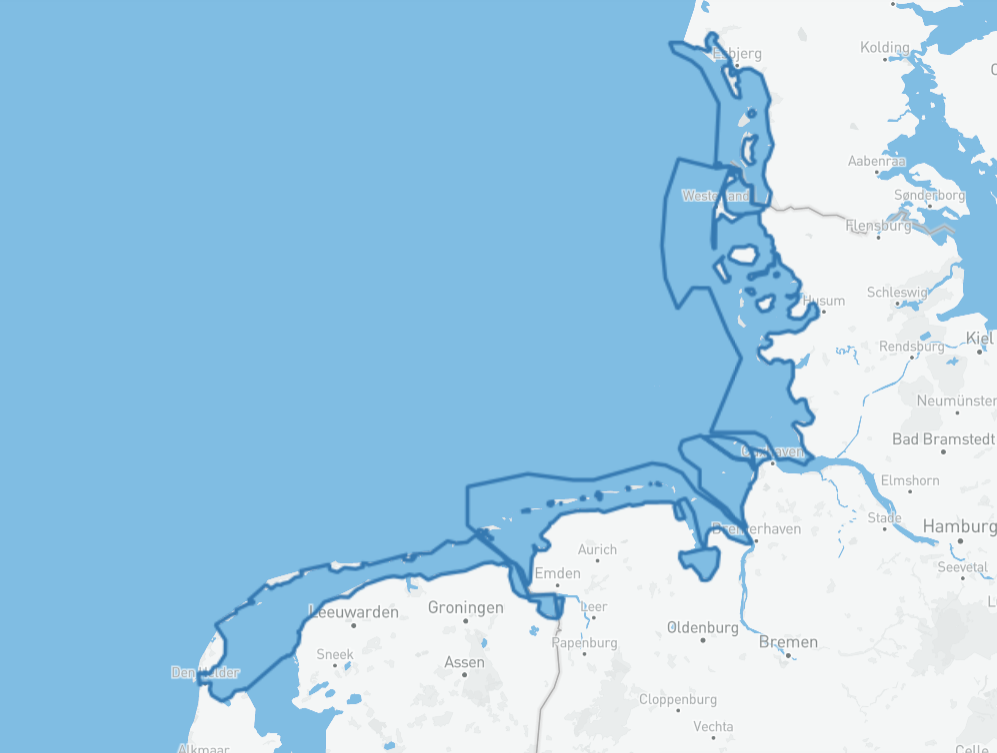
Grens Waddenzee beschermingsgebied
Het Beschermingsgebied (Wadden Sea Conservation Area) verwijst naar het Nederlandse beschermde natuurgebied en de vier nationale parken in de Waddenzee – één in Denemarken en drie in Duitsland. Het Beschermingsgebied heeft een totale oppervlakte van 11.950 km².
[object Object]
Simple
- Date (Publication)
- 2012-11-19
- Status
- Completed
- GEMET – INSPIRE themes, version 1.0
-
-
Grens
-
Internationaal
-
Grens Waddenzee
-
- Use constraints
- Geen gebruiks limitaties
- Access constraints
- Copyright
- Use limitation
-
Geen gebruiks limitaties
- Spatial representation type
- Vector
- Denominator
- None
- Language
- Nederlands; Vlaams
- Topic category
-
- Menselijke medegebruik
))
- Supplemental Information
-
NORTH ATLANTIC OCEAN - NORTH SEA - - WADDEN SEA
- Unique resource identifier
- EPSG:25832
- Distribution format
-
- gml+xml (3.2.1)
- OnLine resource
- Wadden viewer
(WWW:LINK-1.0-http--link)
Bekijk deze data via de Wadden viewer
- OnLine resource
- Download
(WWW:LINK-1.0-http--link)
Download de data via de Wadden viewer
- OnLine resource
- grenzen:trilateral_conservation_area
(OGC:WMS)
WMS
- OnLine resource
- grenzen:trilateral_conservation_area
(OGC:WFS-1.0.0-http-get-capabilities)
WFS
- OnLine resource
- Waddenzee Werelderfgoed
(WWW:LINK-1.0-http--link)
Meer informatie op de website van het Waddenzee Werelderfgoed
- Hierarchy level
- Dataset
Conformance result
- Date (Publication)
- 2010-12-08
- Explanation
-
This data set is conformant with the INSPIRE Implementing Rules for the interoperability of spatial data sets and services
- Pass
- Yes
- Statement
-
Het 'Natuurgebied'/Beschermingsgebied Waddenzee wordt beschreven in de Gezamenlijke Verklaring 2010: In Nederland, de gebieden onder het Ruitbesluit Waddenzee; In Duitsland, de Waddenzee nationale parken en de beschermde gebieden onder de Natuurbeschermingswetten ten zeezijde van de hoofdduin en de grens van brakwater; In Denemarken, het Wild- en Natuurreservaat Waddenzee. Afgesproken uitbreiding tijdens de bijeenkomst van de Waddenzee Raad (WSB) 5 (14-15 maart 2012): Overeenkomst om het Waddenzeegebied uit te breiden om de uitbreiding van het Nedersaksische Nationale Park op te nemen en het Beschermingsgebied uit te breiden om gebieden voor de kust op te nemen. Met de uitbreiding past de oorspronkelijke beschrijving (Gezamenlijke Verklaring 2010) mogelijk niet volledig. De componenten van deze kaart zijn afkomstig van de Trilatérale Waddenzee Samenwerking (TWSC) partners in Denemarken, Duitsland en Nederland.
Metadata
- File identifier
- SSXmEek7Tkaf581wLCN8MgXML
- Metadata language
- Nederlands; Vlaams
- Character set
- UTF8
- Hierarchy level
- Dataset
- Date stamp
- 2026-03-23
- Metadata standard name
-
ISO19115
- Metadata standard version
-
Nederlands metadata profiel op ISO 19115 voor geografie 2.0.0
Overviews
Spatial extent
Provided by